Citing Digimap Collections
Check citation requirements
Remember that the information provided here is only a guide. You must check what citation style you are required to follow, e.g. Harvard System, and ensure your citation meets those requirements.
The main focus of your citation should be to ensure that the user of the citation can identify the same data that was originally used and the source of those data, or that they will have an understanding of what data was used and how you accessed it.
Recommended fields
We recommend including the following fields in any citation of Digimap:
| Field | Example |
|---|---|
| Author | Your name |
| Map title | Durham Cathedral |
| Map format | e.g. PDF, PNG |
| Scale | 1:1250 |
| Data product name | OS MasterMap® |
| Data product date (typically date of publication) | November 2019 |
| Service used | Digimap OS Collection |
| URL of service | https://digimap.edina.ac.uk |
| Date created, downloaded or accessed | 10 November 2020 |
Example citation
Sample citation for a map created in Digimap:
Smith, Claire, “Durham Cathedral”, PDF map, Scale 1:2500, OS MasterMap, November 2019, Ordnance Survey, using Digimap Ordnance Survey Collection, https://digimap.edina.ac.uk/, created 10 November 2020.
Finding the information
There are several sources of the information required to cite.
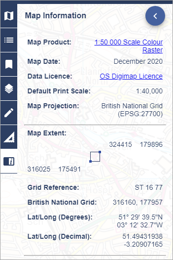
Digimap mapping
In Digimap mapping, check the Map Information panel.

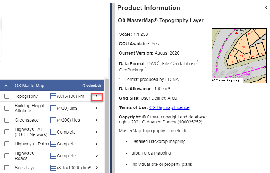
Download Data
Select the arrow to the right of any data product name to open an information box.

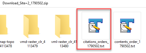
Citations text file
When you download data, a citations-orders text file is included in your data folder. This has a citation for each data product you have downloaded.

Example citations file content:
The citations in this document should be used to reference the maps and data when they have been included in any essays, dissertations or other academic works. You should cite the data even if it doesn’t appear as an image or map in your work if it has been used to generate findings or a new dataset that is used.
There is one entry for each data product and selected area. You can edit the citation if you only use part of the data it covers. Any citations provided below are a guide only and should be given in addition to any requirement to acknowledge sources and copyright of any data used or any local guidance provided:
- OS VectorMap™ District [TIFF geospatial data], Scale 1:25000, Tiles: su77_clipped, Updated: 1 April 2021, Ordnance Survey (GB), Using: EDINA Digimap Ordnance Survey Service, https://digimap.edina.ac.uk, Downloaded: 2021-07-13 09:32:55.241
- OS MasterMap® Topography Layer [DWG geospatial data], Scale 1:1250, Tiles: GB, Updated: 6 August 2020, Ordnance Survey (GB), Using: EDINA Digimap Ordnance Survey Service, https://digimap.edina.ac.uk, Downloaded: 2021-07-13 09:32:55.241
- OS MasterMap®Building Height Attribute [DWG geospatial data], Scale 1:2500, Tiles: su77sw, Updated: 11 March 2020, Ordnance Survey (GB), Using: EDINA Digimap Ordnance Survey Service, https://digimap.edina.ac.uk, Downloaded: 2021-07-13 09:32:55.241
- OS VectorMap® Local [TIFF geospatial data], Scale 1:10000, Tiles: su77sw_clipped, Updated: 1 January 2021, Ordnance Survey (GB), Using: EDINA Digimap Ordnance Survey Service, https://digimap.edina.ac.uk, Downloaded: 2021-07-13 09:32:55.241