Transformations in FME
Transformations to OSGB36 and WGS84 in FME
FME from Safe Software is very powerful and has a lot of built in functionality for coordinate and datum transformations. However, it is a bit obscure in how it actually does the transformations and what parameters it uses and how to change them.
The default transformation used in FME to convert from EPSG: 27700 to WGS84 is a 7-Parameter transformation with the following parameters:
DX: 446 DY: -99 DZ: 544 Scale: -20.8927 rX: -0.945 rY: -0.261 rz: -0.435
This transformation is defined by the NGA (National Geospatial Agency) and is used in the US military transformation program Geotrans [5]. It is also used in ArcGIS and is defined as the NGA_7PAR transformation.
However, it does not have an accuracy statement and is not the 7 parameter transformation recommended by Ordnance Survey.
FME will use this transformation when converting data from OSGB36 to WGS84 either explicitly or implicitly. For instance, if you choose to transform data to Google Earth KML it will implicitly do a transformation to WGS84, for instance when converting OS MasterMap®data from PostGIS (with data in EPSG: 27700) and converting to KML.
It will also choose this transformation if you specify that the source coordinate system as the Esri WKT British National Grid projection.

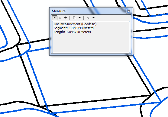
The relative accuracy of this transformation can be seen in the following example which shows the junction of Grange Road and Causewayside. The black data is OS MasterMap®transformed to WGS 84 using the default FME conversion. The blue data is the same data transformed using OSTN02. A difference of approximately 1.8m can be observed,

Using OSTN02 in FME
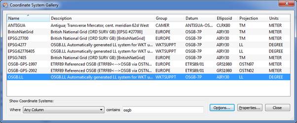
To ensure that FME uses the more accurate OSTN02 transformation it is necessary to define the source coordinate system as: OSGB-GPS-2002.
Setting the source to this coordinate system will automatically ensure that on conversion to WGS84 (or ETRS89) it will use the more accurate OSTN02 transformation as recommended by Ordnance Survey.
Defining your own coordinate system in FME
You can define your own transformation (for instance defining the 7 Parameter Petroleum Shift) in FME but you need to edit some files to do this.
The FME Coordinate System Gallery (Select Tools then Browse Coordinate System) shows the list of coordinate systems available and in the Description filed what transformations it will use.
Summary
For most applications the default transformation is probably acceptable, however with no accuracy statement associated with the NGA transformation it is difficult to tell. If absolute accuracy is not required then the 7 parameter ‘Petroleum Shift’ should be used (but needs to be defined in FME).
However, if transforming OS MasterMap®data, or any data where high accuracy is important using FME, you should ensure that the OSTN02 transformation is being used by defining the source coordinate system as OSGB-GPS-2002.