![]()


![]()
In this Topic Show
This document aims to show how to carry out simple GIS analysis using ArcGIS Online.
Aim
The overall aim of the processes is to create a Graduated Symbol map and a Density map. This process will demonstrate Geocoding postcodes and then performing analysis using spatial joins and creating map outputs.
Required Datasets
A shapefile of boundaries of Wards downloaded from Digimap Ordnance Survey Data Download.
Code-Point Open data for Edinburgh downloaded from Digimap Ordnance Survey Data Download to give a list of all postcode units with centroids in Edinburgh.
Census population information for each postcode unit. We will use Geoconvert (http://geoconvert.mimas.ac.uk/index.html) to get Census population data for postcodes using the code-point postcodes as input.
A background OS map.
|
Step |
Process Description |
ArcGIS Online Tool |
|
1 |
Create an Address Locator to Geocode postcodes using Code-Point Open data. |
Use in-built Geocoder or Geocode externally e.g. in Geoconvert |
|
2 |
Geocode addresses |
Add CSV to Online content and geocode using Esri Geocoder. Note: Uses about 1000 credits to geocode 25,000 points. Instead, use Geoconvert |
|
3 |
Clip points to spatial boundary |
Use the Analysis Tool à Find Existing Locations and query for points inside area. Creates a new layer. |
|
4 |
Calculate populations within boundaries |
Use the Analysis Tool à Summarize Data à Summarize Within to create layer with Ward populations |
|
5 |
Classification and Symbology |
Display using classified graduated symbols or colours |
|
6 |
Create Density Map |
Use the Analysis Tool à Analyze Patterns à Calculate Density to create a vector dataset of classified polygons |
Log on to ArcGIS Online Organisational Account and create a folder in My Content called Population.
To Geocode population postcodes without using credits do the following:
Start Geoconvert
Select “Information about Postcodes” and select Next
Select 2011 UK Census postcode lookup and select Next
Select “Postcode populations” --> “Usually resident persons” AND
Select Location Information -->
Postcode easting (Longitude/WGS84/EPSG:4327)
Postcode easting (Latitude/WGS84/EPSG:4327)
NOTE: coordinates in CSV file need to be in Geographicals
Next
Supply a File of Postcodes, Comma separated with no header and select the location of the Code-Point Open csv dataset (eh.csv). Select Next
Note some postcodes won’t be matched because they are not residential addresses and so have no census data.
Select the Postcode Metadata and Save the file e.g. EH_matched_loc.csv
OR if you are not concerned about credits
Add the Population spreadsheet with postcodes to it.
Go to My Content
Create a New Folder called ”Ed Population” and then select that folder
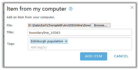
Add Item --> from my computer
Select the CSV file of population by postcode downloaded from the Geoconvert website
Add tags “Population”
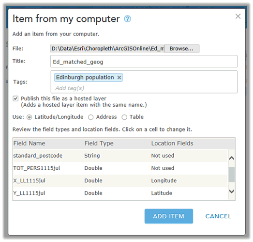
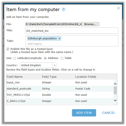
Tell it to use the Address (Toggle Address On)
Set Country to United Kingdom
Click on Location Fields next to “standard_postcode” and set to Postal Code
NOTE: This process will use a lot of credits (approximately 1000 for EH postcodes). Use the alternative method of Geocoding postcodes e.g. use GeoConvert to geocode them if credits are an issue.
Click on Add Item
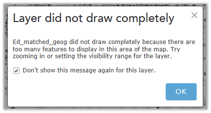
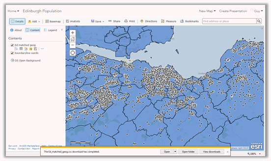
Select Geocoded population Feature Layer and click Open --> Add Layer to map
You will get a message saying “Layer did not draw completely”. Toggle “Don’t show this message again for this layer”.
In the Change Style dialog, in Step 1 “Choose and attribute to show”, select “Show location only”, then click on DONE.
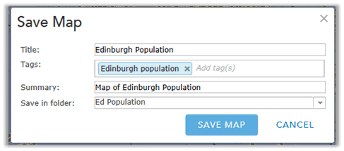
Save the Map
Because the Ward boundary data is national and is so large it needs to be published as a Feature Service to be used in ArcGIS Online (the restrictions on Shapefiles can be found at: http://doc.arcgis.com/en/arcgis-online/reference/shapefiles.htm)
To publish a Shapefile as a Feature Service:
Go to My Content and the Folder Ed Population
Click on Add Item --> From my computer
Add Ward Boundaries Shapefile (note Shapefile needs to be zipped first)
Add the Feature Layer to the Map
Select feature Layer
Open --> Add layer to map
We need to select just the City of Edinburgh from the Ward boundaries
Click on the Filter icon underneath the layer name: 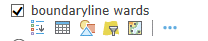
Select where the FILE_NAME is CITY_OF_EDINBURGH
Do a Spatial Query to extract out the postcodes that are only within Edinburgh
Use the Analysis Tool --> Find Locations --> Find Existing Locations
In Step 1, Select the Population point layer (Ed_matched_geog)
Add the Expression: Ed_matched_geog completely within boundaryline_wards
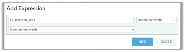
Change the Result layer name to Edinburgh_population and save the results in the folder “Ed Population”
Toggle off “Use current map extent”
Run Analysis
Remove the original geocoded population points
Perform Analysis on the “boundaryline wards” layer
Select “boundaryline wards” layer and click Perform Analysis icon underneath it
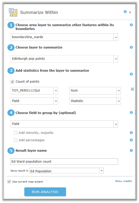
Select Summarize Data à Summarize Within
Step 1: Boundaryline_wards
Step 2: Ed population count
Step 3: TOT_PERS1115jul Statistic=Sum
Step 4: ignore
Step 5: change result layer name to : Ed Ward population count
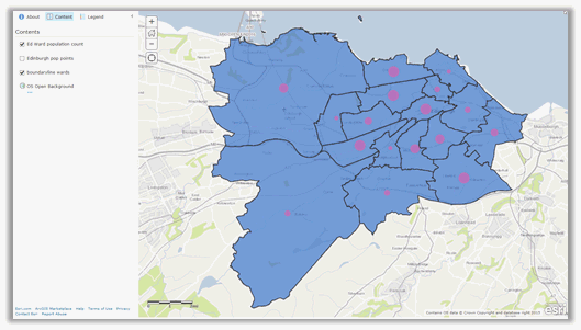
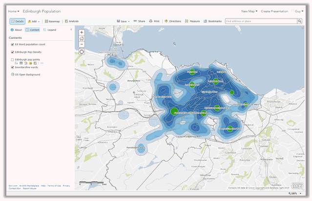
The map will look like:
Set representation to display population as graduated symbols
Select the Ed Ward population count layer
Click on the “Change Style” icon
Choose an attribute to show: Sum TOT_PERS1115jul
Select Counts and Amounts --> Options
Change colour of Symbol
Change size to be Min 4px, Max 40px
Toggle on Classify Data, using Natural Breaks with 5 classes
Click OK and Done
Add Text Labels to Ward Polygons by clicking on the ellipses next to the Ed Ward pop Count layer and select Create Labels. It should automatically choose the “name” attribute to use. Change the style as required.

Select Edinburgh Population point dataset
Click “Perform Analysis” or the “Analysis” button
Select Analyze Patterns --> Calculate Density
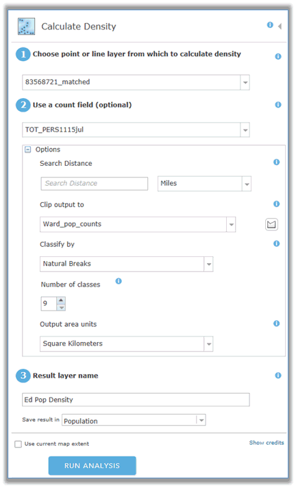
Select Classify by Natural Breaks and number of classes 9
Change Output area units to Kilometres
Change Result Layer name to “Ed pop density” and save it in the folder Population
Toggle off “Use current map extent”
Run Analysis
Select the “Change Style” menu for the “Ed Pop Density” layer
Choose attribute to show: Class
Select “Options” in Counts and Amounts (colour)
Change the colour ramp to something blue that is darker at the top by clicking on : Symbols
Change Outline to “No colour”
Make the lowest band colour completely transparent by using the Transparency Per Feature option.
Click on the “Set from Attribute Values”
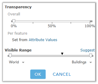
Select the “Class” field for “Set Transparency based on attribute values”
Divided By: None
Move the top slider down so it is less than 2
Change Transparency Range High Values to 0% and Low Values to 100%
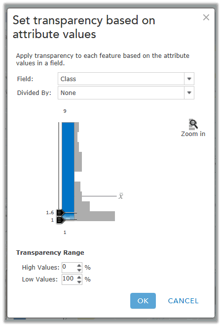
Click OK, OK
Clock DONE
Not found what you are looking for? Please ask a question or give feedback by emailing (digimap@ed.ac.uk) or chatting with the Digimap team.
Share a to this page.
You may also find more information or communicate with us on our Social Media sites:
|
© University of Edinburgh. |