Building Height Attribute
Introduction
Building Height Attribute is an enhancement to OS MasterMap®Topography Layer. It provides a set of height attributes with a buildings theme within OS MasterMap®Topography Layer. It has further been enhanced with the inclusion of tanks, chimney stacks and glasshouses.
The product can be used to make simple 3D visualisations of buildings and structures. Building Height Attribute can be used to enhance the information obtained from OS MasterMap®Topography Layer in a range of applications. It can also be integrated with other Ordnance Survey products such as OS Terrain® 5 andOS MasterMap®Imagery Layer.
Attributes supplied by OS
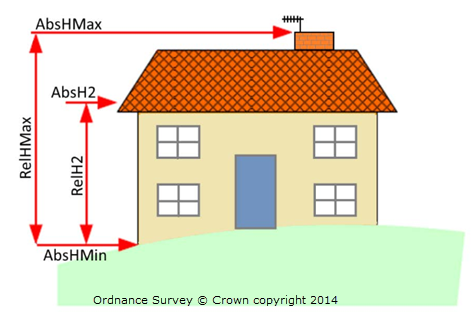
A number of attributes are provided for each building as shown in the image:

- ground level [AbsHMin]
- the base of the roof [AbsH2]
- highest part of the roof [AbsHMax]
Using these three values two additional relative heights are calculated:
- relative height from ground level to the highest part of the roof [RelHMax]
- relative height from ground level to base of the roof [RelH2]
Data formats and size
The data is available in CSV, File Geodatabase and DWG. OS publish the data as a single CSV file containing over 20 million records. This is a very large dataset and can cause data management problems in a desktop environment so EDINA have split the dataset up using the OS 5km grid, allowing you to download the data in tiles for your study area.
Using BHA in popular GIS/CAD software
We provide instructions on using BHA: